
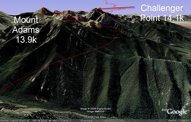
Above: On my way to Challenger Point and then to Crestone Peak which is hidden from view b/c of Challenger point (furthest right peak).
Below: Google Earth view of the same position, but showing the tracklog/path into the most amazing part of the flight!
I had no idea how rewarding this flight would be. It took 2hrs 40 minutes to get 18miles against the strong southerly wind. Multiple times I had given up and headed back.

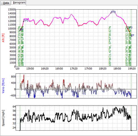
But I’d find better climbs and kept challenging myself to stick to my goal of Crestone. The lift felt like it was erupting and the sink was tremendous in places… Look at the lift on the vario in this shot, right before it continues to disappear and climb off the scale!:

BUT, After 18 miles, it got magical. I had finally turned the corner and the wind was at my side more than in my face.
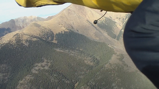
Below: “Turning the corner” – just starting to get up high and about to head into the magic that resides off the right side of this picture…

The lift became plentiful, and the BIG, BIG, BIG craggy 14kft peaks ahead weren’t buried deep in windy rotor air meaning it was now safer to fly closer to them and have a looksee. Just to explain, that 18 miles that took almost 3 hours, the next 9.5 only took 30 minutes!
Below: Google Earth Tracklog in Red.

That half hour spent heading South past the Orange Arrow was pretty boaty, approaching glass off air under a long line of maturing clouds. The below picture shows the line of clouds I followed to get to the distant peaks…

The line of clouds thickened slowly as I kept stretching the umbilical cord…
Finally, more consistent lift and less demons in the air (which were everywhere earlier as I hopped from wave cloud to wave cloud during first 2.5 hours). The adventure of covering new ground for me was renewing and invigorating. People climb these fourteeners and I’m able to cruise beside their big rock cliffs and then climb above the peaks so effortlessly now in the late day air. Since the camera crapped the bed by this time, here’s a Google Earth picture of my favorite part of the flight…

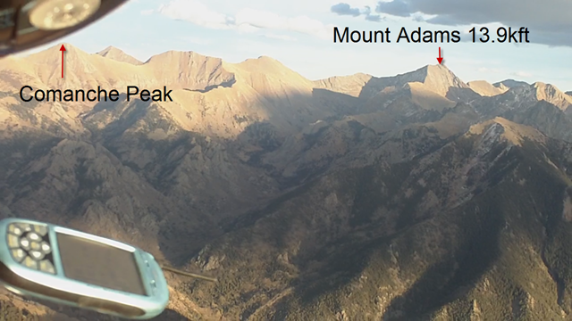
The piece of flying in the above picture was my ultimate reward and highlight of the flight. Making that zig/zag in front of Challenger point/Kit Carson and ogling at the hugeness of it’s rocky cliffs turning orange in the late day sun was more awe-inspiring than when I first looked into the Grand Canyon… Here’s a hikers’ picture looking at Crestone Peak from the Kit Carson Peak.. These peaks are STEEP!!

The cloudstreet I’ve been under kept going to the sand dunes for at least 15 more miles but it’s 25-30 minutes till sunset and I’ve got 27 miles to get back to the LZ and my truck.
Below, you can see the sand dunes in the top right…

In the lifty air, I enjoy the scenery for the first 5 miles back and then pick up speed for half an hour of running the ridge. The VR covered the 27 mile run back to launch in 34 minutes and averaged 51mph(airspeed). My groundspeed was over 80mph sometimes.
I spiraled down in some sink as the crescent moon brightened and landed in a persistent 10-15 mph wind. It’s usually catabatic by dusk, but that didn’t happen till an hour after dark as I broke down the Atos VR by my truck’s headlights. Thanks Mom for driving my truck down, thanks Tiff’n’Larry for the best green chili I’ve ever had, thanks Shawn for bringing your radio into the “natural” hot springs at Valley View and sharing stories. WOW…
“To the Stars through Adversity” is what this flight was all about and strangely, making passes by Challenger Point was a highlight of my year. Looking for the altitude of Challenger Point, I learned that the plaque on top of Challenger Point says, “In Memory of the Crew of Shuttle Challenger, Seven who died accepting the risk, expanding Mankind’s Horizons – January 28 1986, Ad Astra Per Aspera”. It’s a fitting place. Challenger Point stands out among its peers. Here’s to all the adventurer’s that have gone before…
Reference: http://en.wikipedia.org/wiki/Challenger_Point
Airtime: 3:50 (I’ve had 3 flights recently with the same duration WIERD)
Max Altitude: 14,777ft
XC: Out and back 55.1 miles

That is sick!
By: Jason on November 4, 2008
at 7:36 pm
bNPjz2RZYRwFI
By: Gary on January 6, 2009
at 3:24 pm
good evening would like to inform you all a tip on how you can save some money monthly, Getting a conversion
kit for your vehicle will save you hundreds of dollars on gas by switch to an american made fuel ‘Ethonal’.
More americans are upgrading their vehicles to support both fuel types and buying ethonal to fill up your vehicle.
Ethonal is not only an American made fuel, which you’ll be support our economy alot more than buying fuel
that we have to import making us more depended on foreign supplies.
Run your vehicle on a e85 Conversion kit
By: PriettyChiese on August 24, 2010
at 11:20 am